


Cette page vous donne les différences entre la révision choisie et la version actuelle de la page.
|
en:newmap [2010/08/26 13:13] gauthier créée |
en:newmap [2015/02/18 11:05] (version actuelle) |
||
|---|---|---|---|
| Ligne 8: | Ligne 8: | ||
| - | [[http://www.simutrans-france.fr.nf/lib/exe/fetch.php?media=fr:newmap01en.png|{{ :fr:newmap01en.png }}\\ ]] | + | {{ :fr:newmap01en.png }} |
| ==== Dimensions and geography ==== | ==== Dimensions and geography ==== | ||
| Ligne 32: | Ligne 31: | ||
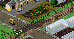
| - | The set elevations are taken in ascending order, from the level zero to the next lowest elevation, the climate wich the height is the lowest is used, from this height to the next one, the climate of the next elevation is used, etc ... For example in this screenshot, from level 0 to 2, the climate is mediterranean, from level 3 to 6 the climate is temperate, from 7 to 8 it's tundra and then it's alpine. | + | The set elevations are taken in ascending order, from the level zero to the next lowest elevation, the climate wich the height is the lowest is used, from this height to the next one, the climate of the next elevation is used, etc … For example in this screenshot, from level 0 to 2, the climate is mediterranean, from level 3 to 6 the climate is temperate, from 7 to 8 it's tundra and then it's alpine. |
| Ligne 44: | Ligne 43: | ||
| - | The summer snowline depends on the alpine climate height set below, the winter snowline can be set. | + | The summer snowline depends on the tundra climate height set below, the winter snowline can be set. |
| - | Ticking the case "no trees" prevents trees from growing on the map (it's possible to plant woods manually while playing). | + | Ticking the case “no trees” prevents trees from growing on the map (it's possible to plant woods manually while playing). |
| The last three parameters of the climate window are used to set rivers which appear on the map, the number of rivers is the number of sources placed on the map, it may be wrong if the map doesn't allow some rivers because of insufficiant length. | The last three parameters of the climate window are used to set rivers which appear on the map, the number of rivers is the number of sources placed on the map, it may be wrong if the map doesn't allow some rivers because of insufficiant length. | ||
| - | |||
| ==== Cities, industries, touristic attractions, timeline ==== | ==== Cities, industries, touristic attractions, timeline ==== | ||